Table of Contents
ToggleAerial View Rendering
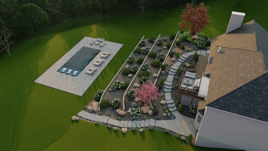
In the rapidly changing realms of architecture, real estate, and urban planning, aerial view rendering represents a remarkable approach. This visualization method provides an overview view of projects, making it ideal to display extensive developments, projects and all of the details of the site surrounding a large development. For marketing context, presentations or planning approvals, aerial view rendering provides an unparalleled approach and represents a nexus between vision and visualization.


What Is Aerial View Rendering?
An aerial view rendering is a type of 3D visualization that illustrates a project from a high angle–in fact, typically from the direction of a drone or aircraft. It is frequently used to depict buildings, landscaping, and the surrounding context from a more complete, top-down view. Unlike traditional ground-level renders, aerial views offer a much wider sense of spatial context, allowing stakeholders the opportunity to see how a project interacts and fits into its environment.
These styles of rendering often show various types of nearby structures, roadways, green spaces, and simply the geographic context, which represents with greater accuracy how the final outcome will feel and look within its actual environment. Whether it is a residential community or large commercial complex, aerial view rendering captures the full scope of the development experience.


Benefits of Aerial View Rendering in Architecture and Real Estate
Aerial view rendering’s strength is its ability to communicate complex ideas in a simplified and engaging visual way. Consider the following benefits:
- Improved Project Comprehension From a top-down perspective, developers, clients, and city planners may work more effectively to understand scale, spatial relationship, and layout. Top-down views are particularly effective for mixed-use development or multiple building projects, where a typical ground render may not go far enough.
- Powerful Marketing Tools Aerial views and renderings provide designers with excellent visuals for brochures, websites, and marketing videos. In particular, aerial renderings can assist real estate agents and marketers in selling the project’s location, highlighting proximity to downtown, transportation hubs, parks, and other amenities that affect decisions.
- Improved Decision-Making Stakeholders and investors can quickly assess the viability of a project, assess zoning impact, and gauge aesthetic appeal of the project. Often visualizations play powerful roles during approval timelines with city planners or directly when firms comment to support funding through banks and financial lenders.
- Easy Integration with Drone PhotographyWhile utilizing aerial perspectives, technology provides designers with tools to combine 3D rendering with imagery captured in drone photography. These combinations enhance the realism of design development, connecting photographic images with digital models to provide extraordinary visual truth.

How Aerial View Rendering Is Created
Creating a compelling aerial view rendering requires a combination of advanced software, architectural knowledge, and creative flair. The process typically involves the following steps:
1. Data Collection & Site Analysis
Architects and visualization teams gather site data, such as topography, nearby structures, and satellite imagery. This helps form a realistic foundation for the rendering.
2. 3D Modeling
Using tools like SketchUp, 3ds Max, or Revit, a detailed 3D model of the project is created. The model includes architectural features, textures, and landscaping elements.
3. Environment and Context Building
The surrounding area is modeled or imported, including roads, trees, neighboring buildings, and terrain. This step ensures the render accurately reflects the project’s context.
4. Lighting and Rendering
The scene is lit to simulate real-world conditions—such as morning or evening sun. High-resolution rendering engines like V-Ray or Lumion are used to produce photorealistic images.
5. Post-Production
Final touches are added using photo editing software. Enhancements like shadows, people, cars, and weather effects increase the realism and appeal of the aerial render.
Benefit of Aerial View Rendering
Although aerial view rendering is most often thought of in architecture and real estate, aerial views can be used across numerous industries.
- Themed Playgrounds:Allow children to escape to dream worlds with themed play areas (pirate, jungle, outer space, etc.).
- Interactive Water Play: Splash pads, water tables, and misting stations provide refreshing water fun on a hot day.
- Natural Playgrounds: Use natural materials such as wood, rocks, and sand to create a manmade natural play area.
- Adventure Course: Provide opportunities for older children to climb walls, cross rope courses, or zip across a rope line.
- Sensory Gardens: A space for calming and sensory engagement that includes fragrant plants, textured surfaces, and soothing sounds.
Conclusion:
Designing play spaces is an art in allowing for creativity, functionality, and safety. 3D rendering helps to visualize a designers idea for children’s spaces, while providing a consideration for design, challenge, and engagement. 3D technology provides opportunities for creating unique play spaces for children that inspire imagination, exploration, and love for nature.