Aerial & Masterplan Renders: The Developer’s Guide
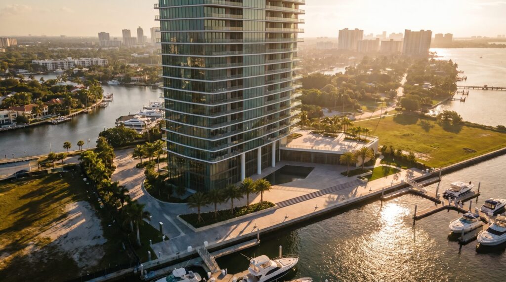
An aerial or masterplan render shows what no ground-level exterior view can: the full site in context — parcel boundaries, phasing, circulation, landscaping, and the relationship between buildings and surrounding infrastructure. Developers need one the moment a project moves beyond a single structure into multi-building, mixed-use, or large-lot territory, or when an investor deck, planning board, or pre-sales campaign requires a bird’s-eye story that a street-level render simply cannot tell.
What Is an Aerial Masterplan Render (and What It Shows Investors)
A masterplan render is a photorealistic 3D image captured from an elevated camera position — typically 200 to 1,500 feet above grade — that visualizes an entire development site as a cohesive whole. Unlike a site plan, it replaces abstract lines and hatch patterns with accurate massing, realistic materials, mature landscaping, and true-to-life lighting conditions.
For investors, that distinction matters enormously. A site plan asks the viewer to mentally translate symbols into space. An aerial render hands them the finished picture: how the residential towers relate to the retail podium, where the amenity deck sits relative to the parking structure, how the project fits the surrounding neighborhood grid. It answers the question “What am I actually buying into?” in a single image.
Key elements a well-executed aerial render communicates:
- Site coverage and density — how much of the parcel is built vs. open space
- Phasing logic — Phase 1 buildings rendered fully, future phases shown as massing or ghost volumes
- Vehicular and pedestrian circulation — driveways, drop-offs, pathways, and parking clearly readable
- Landscape and amenity zones — pools, courtyards, greenways, and buffers in context
- Surrounding context — neighboring parcels, roads, water features, and skyline stitched in from real GIS or satellite data
- Scale and proportion — the project’s footprint relative to adjacent streets and structures
Aerial Render vs. Site Plan: Key Differences for Developer Decks
Both tools communicate site layout, but they serve different audiences and different moments in the sales or approval process.
| Attribute | 2D Site Plan | Aerial Masterplan Render |
|---|---|---|
| Audience | Engineers, planners, permitting staff | Investors, buyers, planning boards, press |
| Reading skill required | High — must interpret symbols and scale | None — photorealistic and intuitive |
| Emotional impact | Minimal | High — conveys lifestyle and quality |
| Phasing communication | Color-coded layers | Rendered vs. massed volumes, clear at a glance |
| Brochure / deck ready | Rarely without graphic treatment | Yes — print and digital ready |
| Revision flexibility | Fast in CAD | Moderate — requires 3D model updates |
The practical takeaway: keep the site plan for technical submissions and pair it with an aerial render for every deck that goes in front of capital partners, city councils, or prospective buyers.
Best Use Cases: Investor Presentations, Approvals, and Pre-Sales
Aerial masterplan renders earn their fee fastest in three specific scenarios:
Investor and Equity Decks
Capital partners review dozens of opportunities. A single compelling aerial render communicates scale, location, and design quality faster than three pages of pro-forma narrative. It anchors the visual story at the front of the deck before financials appear.
Planning and Zoning Approvals
Many planning boards respond better to photorealistic context images than to abstract drawings. Showing commissioners how a project sits within the existing streetscape — with accurate tree canopy, neighboring building heights, and pedestrian zones — reduces objections rooted in uncertainty. Pair the aerial with ground-level exterior renders for a complete approval package.
Pre-Sales and Reservations
For master-planned communities, mixed-use projects, or condo towers, buyers purchasing off-plan need to understand amenities and community layout, not just their individual unit. An aerial render placed on a project website or in a sales center answers “What does the whole community look like?” before a single shovel breaks ground. Developers using real-estate visualization at the pre-sales stage consistently report faster reservation velocity.
What to Provide Your Studio: Site Data, Context, and Scope
The quality and turnaround of an aerial render depends directly on what you hand the studio at kickoff. Incomplete data leads to assumptions, revisions, and delays. Provide as much of the following as possible:
- CAD or Revit site plan — with accurate parcel boundaries, building footprints, and setbacks
- Massing or schematic 3D model — even a rough SketchUp file dramatically reduces modeling time
- GIS or survey data — parcel coordinates so the studio can align satellite or aerial base imagery
- Context buildings — heights and footprints of adjacent structures (public GIS data often sufficient)
- Landscape plan — or at minimum a list of planting zones, turf areas, and hardscape materials
- Phasing diagram — which buildings are Phase 1, which are future phases
- Preferred camera angle — compass orientation, approximate altitude, and any “hero” views to avoid or include
- Brand and color palette — for any graphic overlays, labels, or legend treatments
Drone-Style vs. True Aerial Perspective: Choosing the Right Angle
Not all aerial renders use the same camera altitude, and the choice affects how the image reads.
Drone-Style (Low Aerial, 100–300 ft)
Feels familiar — similar to footage buyers have seen from property drone videos. Shows building facades, rooftop details, and landscaping with good clarity. Best for single-building projects or tight urban infill sites where context beyond the immediate block is less relevant. Also the strongest choice when you want the render to feel continuous with actual drone photography shot on site.
Mid-Level Aerial (300–800 ft)
The workhorse for most masterplan projects. Shows the full site with readable detail on buildings and landscaping while capturing several blocks of surrounding context. Works well in investor decks and planning submittals.
True High Aerial / Satellite-Style (800 ft+)
Best for large-scale master-planned communities, mixed-use districts, or transit-oriented developments where showing the full site boundary and its relationship to major roads, water, or city center is the primary goal. Detail on individual buildings is reduced, but site-wide legibility is maximized.
Most developer projects benefit from at least two aerial angles — a mid-level hero shot and a higher overview — combined with two or three street-level exterior renders for a complete visual package.
How Much Does an Aerial Masterplan Render Cost in 2025?
Aerial renders carry higher production costs than single-building exteriors because they require larger 3D scenes, more complex context modeling, and greater data processing. Scope and complexity drive pricing more than any other variable.
| Project Type | Typical Scope | Relative Investment |
|---|---|---|
| Single-building drone-style aerial | 1 building, minimal context | Lower end |
| Mid-scale masterplan (5–20 buildings) | Full site + 2–3 blocks context | Mid-range |
| Large mixed-use or community masterplan | Multi-phase, extensive context, phasing overlays | Premium |
| Aerial + ground-level package | 1–2 aerials + 3–4 exterior views | Best per-image value |
Bundling aerial renders with ground-level views in a single project scope almost always reduces the per-image cost, since the 3D model built for the aerial is reused for street-level cameras. See our rendering cost guide for a detailed breakdown of what drives pricing across project types.
Combining Aerial Renders with Ground-Level Views for Maximum Impact
The strongest developer visual packages pair aerial context with human-scale street views. Each image type answers a different question buyers and investors ask:
- Aerial render — “Where is this project and how big is it?”
- Street-level exterior render — “What does it feel like to approach or stand in front of this building?”
- Amenity or courtyard render — “What is daily life here like?”
- Interior render — “What does my unit or space look like finished?”
A well-sequenced deck or sales brochure moves the viewer from macro to micro: aerial establishes the whole, exterior renders build desire, interiors close the sale. Studios that handle all render types in-house — including exterior visualization — can maintain consistent lighting, materials, and color grading across every image, which matters for brand cohesion in high-end marketing collateral.
Ready to scope your aerial render package? Contact Ratio Visuals with your site plan and project timeline and we’ll turn around a detailed proposal within one business day.
Frequently Asked Questions
How long does it take to produce an aerial masterplan render?
Turnaround depends on site complexity and how complete your source data is. A single drone-style aerial for a smaller project typically takes 5–8 business days from approved concept. A full masterplan package covering multiple buildings, phasing, and extensive context can run 2–4 weeks. Providing clean CAD files and a rough 3D massing model at kickoff is the single biggest factor in compressing timelines.
Can aerial renders be produced before the design is fully resolved?
Yes — and this is one of their primary values. Aerial renders work well at the schematic design stage using massing volumes for buildings not yet fully detailed. Studios can render Phase 1 buildings with full material detail while showing future phases as simplified massing, clearly communicating the project’s long-term vision without requiring complete construction documents.
What file formats are delivered and how are they used?
Standard delivery is high-resolution TIFF or PNG (typically 4,000–6,000 pixels wide) suitable for large-format print, plus web-optimized JPEGs for digital decks and listings. If the render will be used in a zoning submittal, confirm the required resolution with your planning department before briefing the studio — some jurisdictions specify minimum DPI for printed exhibits.
Do I need a drone flight or real aerial photography to produce an aerial render?
No. A photorealistic aerial render is built entirely in 3D software. The studio uses your site data, publicly available GIS and satellite imagery for surrounding context, and 3D modeling for all buildings and landscaping. No site visit or drone flight is required, which means aerial renders can be produced for projects at any stage — including sites that are still raw land.
How do aerial renders hold up as the design changes?
Revisions to an aerial render are straightforward as long as the 3D model is maintained in the studio’s pipeline. Minor changes — material swaps, landscape adjustments, adding or removing a building — are typically handled as revision rounds included in the original scope. Significant design changes that alter massing or site layout will require additional modeling time and are usually quoted as a change order.